Habitat structure shapes temperate reef assemblages across regional environmental gradients

Habitat structure shapes temperate reef assemblages across regional environmental gradients

Jackson-Bué T, Evans AJ, Lawrence PJ, Brooks PR, Ward SL, Jenkins SR, Moore PJ, Crowe TP, Neill SP, Davies AJ

Intertidal artificial habitats are proliferating, but are generally simpler in structure and host lower biodiversity than natural rocky reefs. Eco-engineering aims to enhance the biodiversity of coastal infrastructure, often through physical structural modifications that mimic topographic properties of natural shores. Relationships between biotic assemblages and structural properties of natural and artificial reefs have been extensively studied at sampling scales of up to 1 m2. But evidence that quantified local structural variation has an appreciable influence on biotic assemblages, at a shore-wide scale across regional environmental gradients, is lacking. Here we addressed this knowledge gap with an observational study at 32 natural and artificial intertidal reef sites in Wales, UK. We used multivariate community analysis and permutation tests to examine associations between local physical structure, regional environmental variables and sessile biotic assemblages. A potential influence of local habitat structure on assemblage composition was evident across regional-scale environmental gradients. Compared to natural sites, artificial reefs had lower taxonomic richness, distinct and more variable assemblage composition, and different physical structure. After removing the effect of habitat (natural or artificial), canonical correspondence analysis showed that environmental variables (wave exposure, sea surface temperature and salinity variation), along with two metrics of physical structure (standard deviation in log-transformed detrended roughness and skewness of surface verticality, both at 0.5 m scale), explained 40 % of the variation in assemblage composition among sites. The two structural metrics independently explained 14.5 % of the variation. Associations identified between individual taxa and environmental variables indicated that sites with a higher proportion of horizontal surfaces hosted more canopy macroalgae, which in turn support other algae and invertebrates. Our findings provide evidence to inform scaling-up of structural eco-engineering interventions from experimental contexts to enhance the biodiversity of coastal infrastructure across regional extents.

[sendpaper paperurl=”2023_Jackson-Bue_STOTEN.pdf”]

Full Citation

Jackson-Bué T, Evans AJ, Lawrence PJ, Brooks PR, Ward SL, Jenkins SR, Moore PJ, Crowe TP, Neill SP, Davies AJ (2024) Habitat structure shapes temperate reef assemblages across regional environmental gradients. Science of The Total Environment 906: 167494

Manuscript DOI

https://doi.org/10.1016/j.scitotenv.2023.167494

Host density and anthropogenic stress are drivers of variability in dark spot disease in Siderastrea siderea across the Florida Reef Tract

Host density and anthropogenic stress are drivers of variability in dark spot disease in Siderastrea siderea across the Florida Reef Tract

Aeby GS, Williams GJ, Whitall DR, Davies AJ, Fromuth E, Walker BK

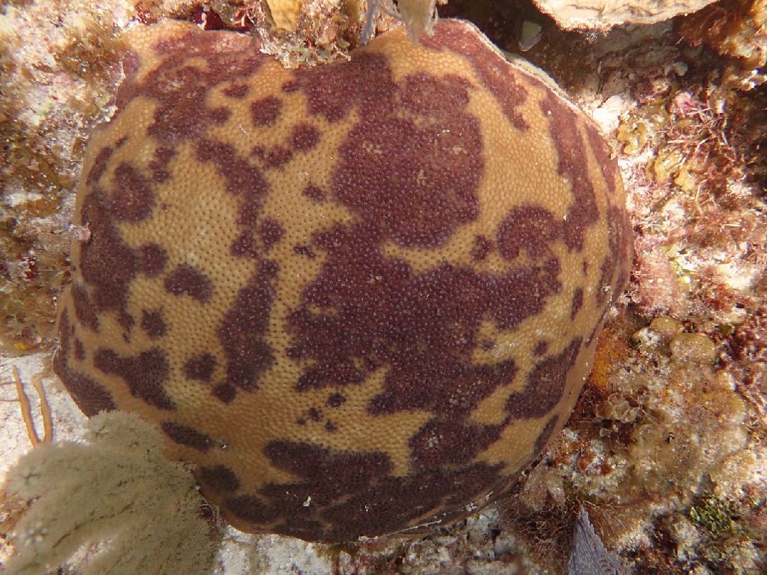
Dark spot disease (DSD) was first reported within Florida’s coral reefs in the 1990s but factors affecting its spatial distribution have not been well studied. We used a 14-year (2005–2019) coral monitoring data set, utilizing 2242 surveys collected along Florida’s coral reefs (about 530 linear km) to explore the spatial and temporal patterns of DSD occurrence. We built predictive statistical models to test for correlations between a suite of environmental and human impact factors and the occurrence of DSD in the reef coral, Siderastrea siderea. DSD in S. siderea is a chronic disease which occurred in all 14 years of the study. Annual DSD prevalence ranged from 0.45% to 4.4% and the proportion of survey sites that had DSD ranged from 4.8% to 30.9%. During the study period, DSD became more widespread across Florida’s coral reefs and affected a higher proportion of S. siderea populations. Spatial variations in DSD correlated with environmental and human factors which together explained 64.4% of the underlying variability. The most influential factors were concentration of silica in the surface waters (a proxy for freshwater input), the total number of coral hosts, and distance to septic areas. DSD occurred in all regions, but the highest cumulative prevalence occurred in the upper Keys on reefs around major urban centers with links to coastal water discharges. Our results support the hypothesis that coastal water quality is a key component of DSD disease dynamics in Florida and provides motivation for addressing land–sea connections to ameliorate disease occurrence in the region.

Full Citation

Aeby GS, Williams GJ, Whitall DR, Davies AJ, Fromuth E, Walker BK (In press) Host density and anthropogenic stress are drivers of variability in dark spot disease in Siderastrea siderea across the Florida Reef Tract. Bulletin of Marine Science

Manuscript DOI

https://doi.org/10.5343/bms.2022.0063

Long distance dispersal and oceanographic fronts shape the connectivity of the keystone sponge Phakellia ventilabrum in the deep northeast Atlantic

Long distance dispersal and oceanographic fronts shape the connectivity of the keystone sponge Phakellia ventilabrum in the deep northeast Atlantic

Taboada S, Whiting C, Wang S, Ríos P, Davies AJ, Mienis F, Kenchington E, Cárdenas P, Cranston A, Koutsouveli V, Cristobo J, Rapp HT, Drewery J, Baldó F, Morrow C, Picton B, Xavier JR, Arias MB, Leiva C, Riesgo A

Abstract

Little is known about dispersal in deep-sea ecosystems, especially for sponges, which are abundant ecosystem engineers. Understanding patterns of gene flow in deep-sea sponges is essential, especially in areas where rising pressure from anthropogenic activities makes difficult to combine management and conservation. Here, we combined population genomics and oceanographic modelling to understand how Northeast Atlantic populations (Cantabrian Sea to Norway) of the deep-sea sponge Phakellia ventilabrum are connected. The analysis comprised ddRADseq derived SNP datasets of 166 individuals collected from 57 sampling stations from 17 different areas, including two Marine Protected Areas, one Special Area of Conservation and other areas with different levels of protection. The 4,017 neutral SNPs used indicated high connectivity and panmixis amongst the majority of areas (Ireland to Norway), spanning ca. 2,500-km at depths of 99–900 m. This was likely due to the presence of strong ocean currents allowing long-distance larval transport, as supported by our migration analysis and by 3D particle tracking modelling. On the contrary, the Cantabrian Sea and Roscoff (France) samples, the southernmost areas in our study, appeared disconnected from the remaining areas, probably due to prevailing current circulation patterns and topographic features, which might be acting as barriers for gene flow. Despite this major genetic break, our results suggest that all protected areas studied are well-connected with each other. Interestingly, analysis of SNPs under selection replicated results obtained for neutral SNPs. The relatively low genetic diversity observed along the study area, though, highlights the potential fragility of this species to changing climates, which might compromise resilience to future threats.

[sendpaper paperurl=”2023_Taboada.pdf”]

Full Citation

Taboada S, Whiting C, Wang S, Ríos P, Davies AJ, Mienis F, Kenchington E, Cárdenas P, Cranston A, Koutsouveli V, Cristobo J, Rapp HT, Drewery J, Baldó F, Morrow C, Picton B, Xavier JR, Arias MB, Leiva C, Riesgo A (2023) Long distance dispersal and oceanographic fronts shape the connectivity of the keystone sponge Phakellia ventilabrum in the deep northeast Atlantic. Front Mar Sci 10

Manuscript DOI

https://doi.org/10.3389/fmars.2023.1177106

Predicting the spatial expansion of an animal population with presence-only data

Predicting the spatial expansion of an animal population with presence-only data

Barton O, Healey JR, Cordes LS, Davies AJ, Shannon G

Predictive models can improve the efficiency of wildlife management by guiding actions at the local, landscape and regional scales. In recent decades, a vast range of modelling techniques have been developed to predict species distributions and patterns of population spread. However, data limitations often constrain the precision and biological realism of models, which make them less useful for supporting decision-making. Complex models can also be challenging to evaluate, and the results are often difficult to interpret for wildlife management practitioners. There is therefore a need to develop techniques that are appropriately robust, but also accessible to a range of end users. We developed a hybrid species distribution model that utilises commonly available presence-only distribution data and minimal demographic information to predict the spread of roe deer (Capreolus caprelous) in Great Britain. We take a novel approach to representing the environment in the model by constraining the size of habitat patches to the home-range area of an individual. Population dynamics are then simplified to a set of generic rules describing patch occupancy. The model is constructed and evaluated using data from a populated region (England and Scotland) and applied to predict regional-scale patterns of spread in a novel region (Wales). It is used to forecast the relative timing of colonisation events and identify important areas for targeted surveillance and management. The study demonstrates the utility of presence-only data for predicting the spread of animal species and describes a method of reducing model complexity while retaining important environmental detail and biological realism. Our modelling approach provides a much-needed opportunity for users without specialist expertise in computer coding to leverage limited data and make robust, easily interpretable predictions of spread to inform proactive population management.

[sendpaper paperurl=”2023_Barton_Eco_Evo.pdf”]

Full Citation

Barton O, Healey JR, Cordes LS, Davies AJ, Shannon G (2023) Predicting the spatial expansion of an animal population with presence‐only data. Eco Evo 13

Manuscript DOI

https://doi.org/10.1002/ece3.10778

Predicting the spatial expansion of an animal population with presence-only data

Predicting the spatial expansion of an animal population with presence-only data

Barton O, Healey JR, Cordes LS, Davies AJ, Shannon G

Predictive models can improve the efficiency of wildlife management by guiding actions at the local, landscape and regional scales. In recent decades, a vast range of modelling techniques have been developed to predict species distributions and patterns of population spread. However, data limitations often constrain the precision and biological realism of models, which make them less useful for supporting decision-making. Complex models can also be challenging to evaluate, and the results are often difficult to interpret for wildlife management practitioners. There is therefore a need to develop techniques that are appropriately robust, but also accessible to a range of end users. We developed a hybrid species distribution model that utilises commonly available presence-only distribution data and minimal demographic information to predict the spread of roe deer (Capreolus caprelous) in Great Britain. We take a novel approach to representing the environment in the model by constraining the size of habitat patches to the home-range area of an individual. Population dynamics are then simplified to a set of generic rules describing patch occupancy. The model is constructed and evaluated using data from a populated region (England and Scotland) and applied to predict regional-scale patterns of spread in a novel region (Wales). It is used to forecast the relative timing of colonisation events and identify important areas for targeted surveillance and management. The study demonstrates the utility of presence-only data for predicting the spread of animal species and describes a method of reducing model complexity while retaining important environmental detail and biological realism. Our modelling approach provides a much-needed opportunity for users without specialist expertise in computer coding to leverage limited data and make robust, easily interpretable predictions of spread to inform proactive population management.

[sendpaper paperurl=”2023_Barton_Eco_Evo.pdf”]

Full Citation

Barton O, Healey JR, Cordes LS, Davies AJ, Shannon G (2023) Predicting the spatial expansion of an animal population with presence‐only data. Eco Evo 13

Manuscript DOI

https://doi.org/10.1002/ece3.10778

Beyond the tip of the seamount: Distinct megabenthic communities found beyond the charismatic summit sponge ground on an arctic seamount (Schulz Bank, Arctic Mid-Ocean Ridge)

Beyond the tip of the seamount: Distinct megabenthic communities found beyond the charismatic summit sponge ground on an arctic seamount (Schulz Bank, Arctic Mid-Ocean Ridge)

H.K. Meyer, A.J.Davies, E.M.Roberts, J.R. Xavier, P.A. Ribeiro, H.Glenner, S.-R. Birkely, H.T.Rapp

Abstract

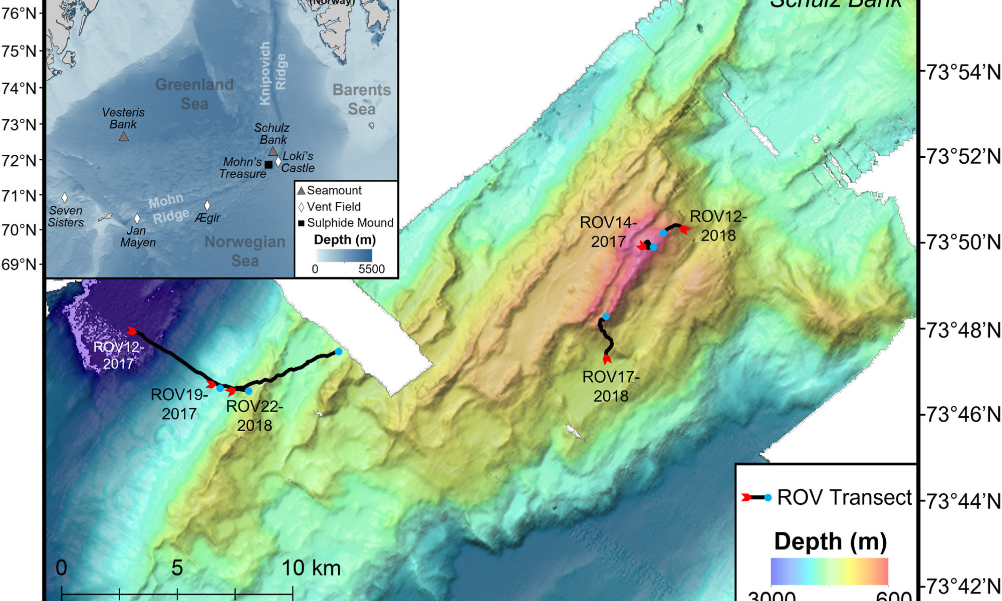
Our understanding of the benthic communities on arctic seamounts and descriptions of such communities in habitat classification systems are limited. In recent years, Schulz Bank (73°52′N 7°30′E), a seamount on the Arctic Mid-Ocean Ridge (AMOR), has become well studied but the work has primarily focused on an arctic sponge ground at the summit. This has compounded a general assumption that the most biologically interesting community is on the summit alone. With the potential threat of deep-sea mining on nearby sites on AMOR, it is crucial to form a baseline understanding of the benthic megafaunal communities not only on the summit, but on the slopes and base of the seamount as well. Using video footage collected by a remotely operated vehicle in 2017 and 2018 to survey the seamount from 2700 to 580 m depth, several distinct megafauna communities on Schulz Bank were identified. Specifically, five biotopes, two of which were dominated by large structure-forming sponges, appeared to follow a depth gradient and change with the type of substrata present. The sponge-dominated communities on the summit and lower slope had the highest average community densities and number of morphotaxa per image compared to the upper slope and seamount base communities. Most notably, sponge-dominated bedrock walls on the lower slopes challenge the assumption that the summit is the most dense and diverse community on Schulz Bank. The results from this study lay the foundation for future research and conservation efforts of arctic sponge grounds by looking beyond the seamount summit to bring a full view of enigmatic sponge dominated ecosystems.

[sendpaper paperurl=”2022_Meyer.pdf”]

Full Citation

Meyer HK, Davies AJ, Roberts EM, Xavier JR, Ribeiro PA, Glenner H, Birkely S_R, Rapp HT (2022) Beyond the tip of the seamount: Distinct megabenthic communities found beyond the charismatic summit sponge ground on an arctic seamount (Schulz Bank, Arctic Mid-Ocean Ridge). Deep-sea Research Vol 1

Manuscript DOI

https://doi.org/10.1016/j.dsr.2022.103920

Three-dimensional digital mapping of ecosystems: a new era in spatial ecology

Three-dimensional digital mapping of ecosystems: a new era in spatial ecology

D’Urban Jackson T, Williams GJ, Walker-Springett G, Davies AJ

https://doi.org/10.1016/j.dsr.2019.103147

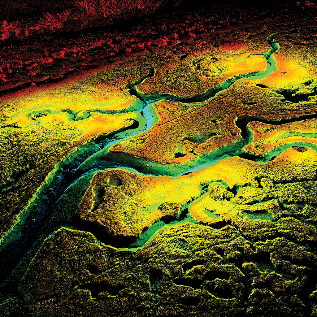
Ecological processes occur over multiple spatial, temporal and thematic scales in three-dimensional (3D) ecosystems. Characterizing and monitoring change in 3D structure at multiple scales is challenging within the practical constraints of conventional ecological tools. Remote sensing from satellites and crewed aircraft has revolutionized broad-scale spatial ecology, but fine-scale patterns and processes operating at sub-metre resolution have remained understudied over continuous extents. We introduce two high-resolution remote sensing tools for rapid and accurate 3D mapping in ecology—terrestrial laser scanning and structure-from-motion photogrammetry. These technologies are likely to become standard sampling tools for mapping and monitoring 3D ecosystem structure across currently under-sampled scales. We present practical guidance in the use of the tools and address barriers to widespread adoption, including testing the accuracy of structure-from-motion models for ecologists. We aim to highlight a new era in spatial ecology that uses high-resolution remote sensing to interrogate 3D digital ecosystems.

D’Urban Jackson Tim, Williams Gareth J., Walker-Springett Guy and Davies Andrew J. Three-dimensional digital mapping of ecosystems: a new era in spatial ecology. Proc. R. Soc. B, 287. http://doi.org/10.1098/rspb.2019.2383


Specific niche requirements underpin multidecadal range edge stability, but may introduce barriers for climate change adaptation

Specific niche requirements underpin multidecadal range edge stability, but may introduce barriers for climate change adaptation

Firth LB, Harris D, Blaze JA, Marzloff MP, Boyé A, Miller PI, Curd A, Vasquez M, Nunn JD, O’Connor NE, Power AM, Mieszkowska N, O’Riordan RM, Burrows MT, Bricheno LM, Knights AM, Nunes FLD, Bordeyne F, Bush LE, Byers JE, David C, Davies AJ, Dubois SF, Edwards H, Foggo A, Grant L, Green JAM, Gribben PE, Lima FP, McGrath D, Noël LMLJ, Seabra R, Simkanin C, Hawkins SJ (2021) Specific niche requirements underpin multidecadal range edge stability, but may introduce barriers for climate change adaptation. Diversity and Distributions 27(4): 668-683.

Aim

To investigate some of the environmental variables underpinning the past and present distribution of an ecosystem engineer near its poleward range edge.

Location

>500 locations spanning >7,400 km around Ireland.

Methods

We collated past and present distribution records on a known climate change indicator, the reef‐forming worm Sabellaria alveolata (Linnaeus, 1767) in a biogeographic boundary region over 182 years (1836–2018). This included repeat sampling of 60 locations in the cooler 1950s and again in the warmer 2000s and 2010s. Using species distribution modelling, we identified some of the environmental drivers that likely underpin S. alveolata distribution towards the leading edge of its biogeographical range in Ireland.

Results

Through plotting 981 records of presence and absence, we revealed a discontinuous distribution with discretely bounded sub‐populations, and edges that coincide with the locations of tidal fronts. Repeat surveys of 60 locations across three time periods showed evidence of population increases, declines, local extirpation and recolonization events within the range, but no evidence of extensions beyond the previously identified distribution limits, despite decades of warming. At a regional scale, populations were relatively stable through time, but local populations in the cold Irish Sea appear highly dynamic and vulnerable to local extirpation risk. Contemporary distribution data (2013–2018) computed with modelled environmental data identified specific niche requirements which can explain the many distribution gaps, namely wave height, tidal amplitude, stratification index, then substrate type.

Main conclusions

In the face of climate warming, such specific niche requirements can create environmental barriers that may prevent species from extending beyond their leading edges. These boundaries may limit a species’ capacity to redistribute in response to global environmental change.
[sendpaper paperurl=”2021_Firth.pdf”]

Full Citation

Firth LB, Harris D, Blaze JA, Marzloff MP, Boyé A, Miller PI, Curd A, Vasquez M, Nunn JD, O’Connor NE, Power AM, Mieszkowska N, O’Riordan RM, Burrows MT, Bricheno LM, Knights AM, Nunes FLD, Bordeyne F, Bush LE, Byers JE, David C, Davies AJ, Dubois SF, Edwards H, Foggo A, Grant L, Green JAM, Gribben PE, Lima FP, McGrath D, Noël LMLJ, Seabra R, Simkanin C, Hawkins SJ (2021) Specific niche requirements underpin multidecadal range edge stability, but may introduce barriers for climate change adaptation. Diversity and Distributions 27(4): 668-683.

Manuscript DOI

https://onlinelibrary.wiley.com/doi/10.1111/ddi.13224

Replicating natural topography on marine artificial structures – A novel approach to eco-engineering

Replicating natural topography on marine artificial structures – A novel approach to eco-engineering

Evans AJ, Lawrence PJ, Natanzi AS, Moore PJ, Davies AJ, Crowe TP, McNally C, Thompson B, Dozier AE, Brooks PR

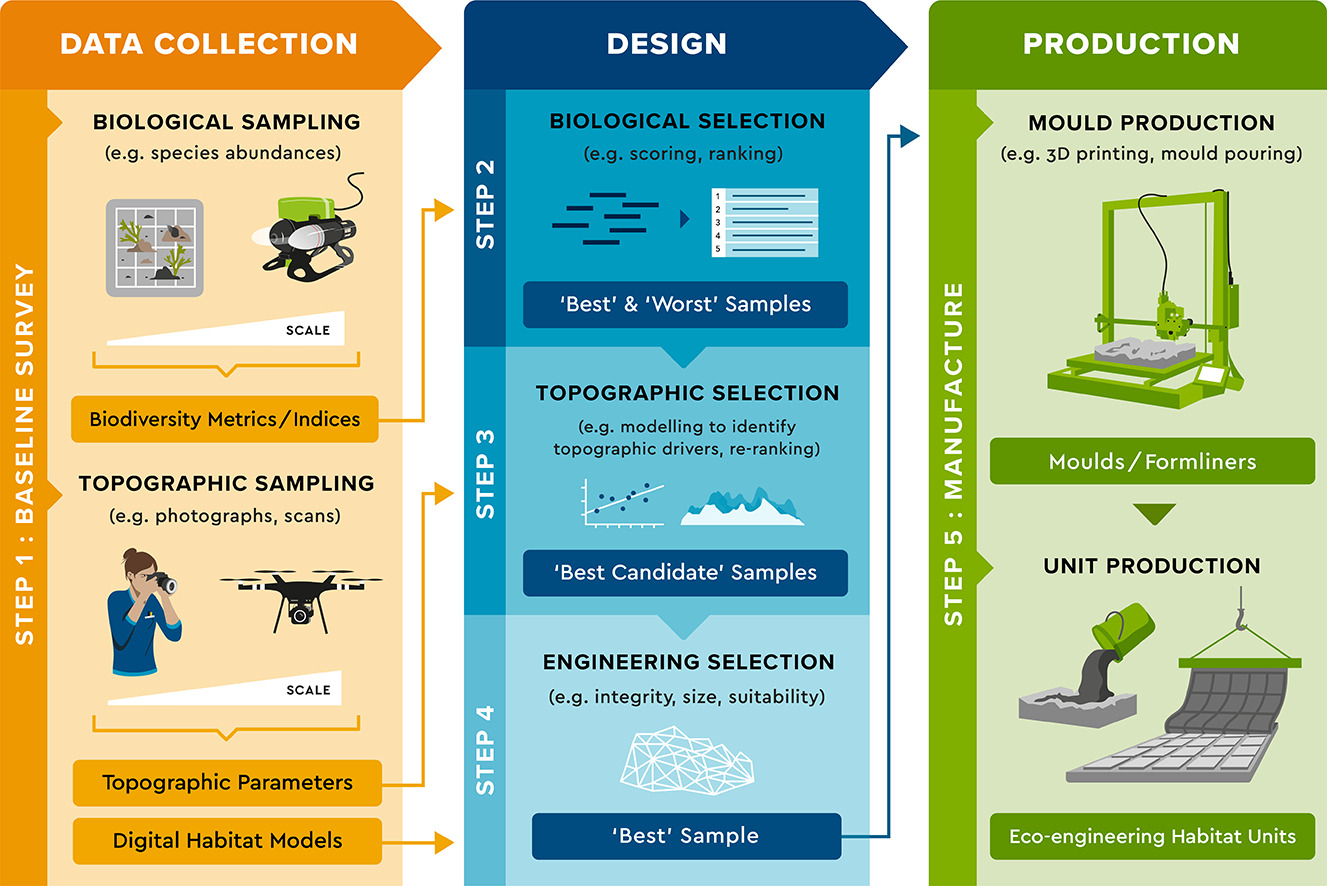
Ocean sprawl is a growing threat to marine and coastal ecosystems globally, with wide-ranging consequences for natural habitats and species. Artificial structures built in the marine environment often support less diverse communities than natural rocky marine habitats because of low topographic complexity. Some structures can be eco-engineered to increase their complexity and promote biodiversity. Tried-and-tested eco-engineering approaches include building-in habitat designs to mimic features of natural reef topography that are important for biodiversity. Most designs mimic discrete microhabitat features like crevices or holes and are geometrically-simplified. Here we propose that directly replicating the full fingerprint of natural reef topography in habitat designs makes a novel addition to the growing toolkit of eco-engineering options. We developed a five-step process for designing natural topography-based eco-engineering interventions for marine artificial structures. Given that topography is highly spatially variable in rocky reef habitats, our targeted approach seeks to identify and replicate the ‘best’ types of reef topography to satisfy specific eco-engineering objectives. We demonstrate and evaluate the process by designing three natural topography-based habitat units for intertidal structures, each targeting one of three hypothetical eco-engineering objectives. The process described can be adapted and applied according to user-specific priorities. Expanding the toolkit for eco-engineering marine structures is crucial to enable ecologically-informed designs that maximise biodiversity benefits from burgeoning ocean sprawl.
[sendpaper paperurl=”2021_Evans.pdf”]

Full Citation

Evans AJ, Lawrence PJ, Natanzi AS, Moore PJ, Davies AJ, Crowe TP, McNally C, Thompson B, Dozier AE, Brooks PR (2021). Replicating natural topography on marine artificial structures – A novel approach to eco-engineering. Ecological Engineering 160, 106144

Manuscript DOI

https://doi.org/10.1016/j.ecoleng.2020.106144

Musical Chairs on Temperate Reefs: Species Turnover and Replacement Within Functional Groups Explain Regional Diversity Variation in Assemblages Associated With Honeycomb Worms

Musical Chairs on Temperate Reefs: Species Turnover and Replacement Within Functional Groups Explain Regional Diversity Variation in Assemblages Associated With Honeycomb Worms

Alexandre Muller, Camille Poitrimol, Flávia L. D. Nunes, Aurélien Boyé, Amelia Curd, Nicolas Desroy, Louise B. Firth, Laura Bush, Andrew J. Davies, Fernando P. Lima, Martin P. Marzloff, Claudia Meneghesso, Rui Seabra and Stanislas F. Dubois1

Abstract

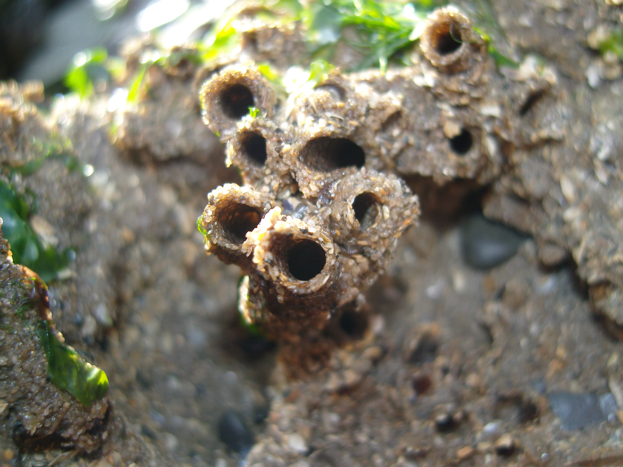
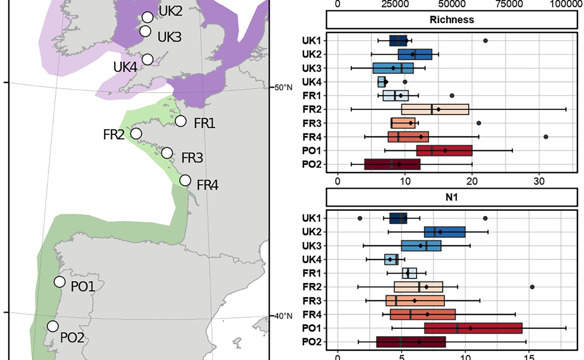
Reef-building species are recognized as having an important ecological role and as generally enhancing the diversity of benthic organisms in marine habitats. However, although these ecosystem engineers have a facilitating role for some species, they may exclude or compete with others. The honeycomb worm Sabellaria alveolata (Linnaeus, 1767) is an important foundation species, commonly found from northwest Ireland to northern Mauritania, whose reef structures increase the physical complexity of the marine benthos, supporting high levels of biodiversity. Local patterns and regional differences in taxonomic and functional diversity were examined in honeycomb worm reefs from 10 sites along the northeastern Atlantic to explore variation in diversity across biogeographic regions and the potential effects of environmental drivers. While taxonomic composition varied across the study sites, levels of diversity remained relatively constant along the European coast. Assemblages showed high levels of species turnover compared to differences in richness, which varied primarily in response to sea surface temperatures and sediment content, the latter suggesting that local characteristics of the reef had a greater effect on community composition than the density of the engineering species. In contrast, the functional composition of assemblages was similar regardless of taxonomic composition or biogeography, with five functional groups being observed in all sites and only small differences in abundance in these groups being detected. Functional groups represented primarily filter-feeders and deposit-feeders, with the notable absence of herbivores, indicating that the reefs may act as biological filters for some species from the local pool of organisms. Redundancy was observed within functional groups that may indicate that honeycomb worm reefs can offer similar niche properties to its associated assemblages across varying environmental conditions. These results highlight the advantages of comparing taxonomic and functional metrics, which allow identification of a number of ecological processes that structure marine communities.

[sendpaper paperurl=”2021_Muller.pdf”]

Full Citation

Muller A, Poitrimol C, Nunes FLD, Boyé A, Curd A, Desroy N, Firth LB, Bush L, Davies AJ, Lima FP, Marzloff MP, Meneghesso C, Seabra R, Dubois SF (2021) Musical Chairs on Temperate Reefs: Species Turnover and Replacement Within Functional Groups Explain Regional Diversity Variation in Assemblages Associated With Honeycomb Worms. Front Mar Sci 8

Manuscript DOI

https://dx.doi.org/10.3389/fmars.2021.654141