Systematic Conservation Planning at an Ocean Basin Scale: Identifying a Viable Network of Deep-Sea Protected Areas in the North Atlantic and the Mediterranean

Systematic Conservation Planning at an Ocean Basin Scale: Identifying a Viable Network of Deep-Sea Protected Areas in the North Atlantic and the Mediterranean

Magali Combes, Sandrine Vaz, Anthony Grehan, Telmo Morato, Sophie Arnaud-Haond, Carlos Dominguez-Carrió, Alan Fox, José Manuel González-Irusta, David Johnson, Oisín Callery, Andrew Davies, Laurence Fauconnet, Ellen Kenchington, Covadonga Orejas, J. Murray Roberts, Gerald Taranto and Lénaick Menot

Abstract

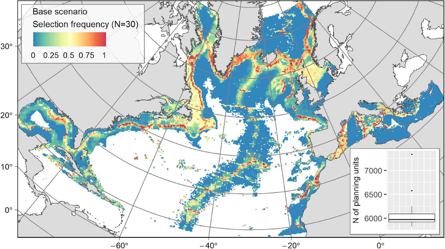
Designing conservation networks requires a well-structured framework for achieving essential objectives such as connectivity, replication or viability, and for considering local management and socioeconomic stakes. Although systematic conservation planning (SCP) approaches are increasingly used to inform such networks, their application remains challenging in large and poorly researched areas. This is especially the case in the deep sea, where SCP has rarely been applied, although growing awareness of the vulnerability of deep-sea ecosystems urges the implementation of conservation measures from local to international levels. This study aims to structure and evaluate a framework for SCP applicable to the deep sea, focusing on the identification of conservation priority networks for vulnerable marine ecosystems (VMEs), such as cold-water coral reefs, sponge grounds, or hydrothermal vents, and for key demersal fish species. Based on multi-objective prioritization, different conservation scenarios were investigated, allowing the impact of key elements such as connectivity and conservation cost to be evaluated. Our results show that continental margin slopes, the Mid-Atlantic Ridge, and deeper areas of large and productive shelves housing fishing grounds appeared as crucial zones for preserving the deep-sea biodiversity of the North Atlantic, and within the limitations imposed by the data available, of the Mediterranean. Using biologically-informed connectivity led to a more continuous and denser conservation network, without increasing the network size. Even when minimizing the overlap with socioeconomic activities, the inclusion of exploited areas was necessary to fulfil conservation objectives. Such areas included continental shelf fishing grounds for demersal fish species, and areas covered by deep-sea mining exploration contracts for hydrothermal vent communities. Covering 17% of the study area and protecting 55% of each feature on average, the identified priority network held a high conservation potential. However, these areas still suffer from poor protection, with 30% of them benefiting from some form of recognition and 11% only from protection against trawling. Integrating them into current marine spatial planning (MSP) discussions could foster the implementation of a basin-scale conservation network for the deep sea. Overall, this work established a framework for developing large-scale systematic planning, useful for managing Areas Beyond National Jurisdiction (ABNJ).

[sendpaper paperurl=”Combes_2021.pdf”]

Full Citation

Combes M, Vaz S, Grehan A, Morato T, Arnaud-Haond S, Dominguez-Carrió C, Fox A, González-Irusta JM, Johnson D, Callery O, Davies A, Fauconnet L, Kenchington E, Orejas C, Roberts JM, Taranto G, Menot L (2021) Systematic Conservation Planning at an Ocean Basin Scale: Identifying a Viable Network of Deep-Sea Protected Areas in the North Atlantic and the Mediterranean. Front Mar Sci 8
Manuscript DOI

https://doi.org/10.3389/fmars.2021.611358

Coral reef resilience differs among islands within the Gulf of Mannar, southeast India, following successive coral bleaching events

Coral reef resilience differs among islands within the Gulf of Mannar, southeast India, following successive coral bleaching events

K. Diraviya Raj, Greta S. Aeby, G. Mathews, Gareth J. Williams, Jamie M. Caldwell, R. L. Laju, M. Selva Bharath, P. Dinesh Kumar, A. Arasamuthu, N. Gladwin Gnana Asir, Lisa M. Wedding, Andrew J. Davies, Monica M. Moritsch, J. K. Patterson Edward

Abstract

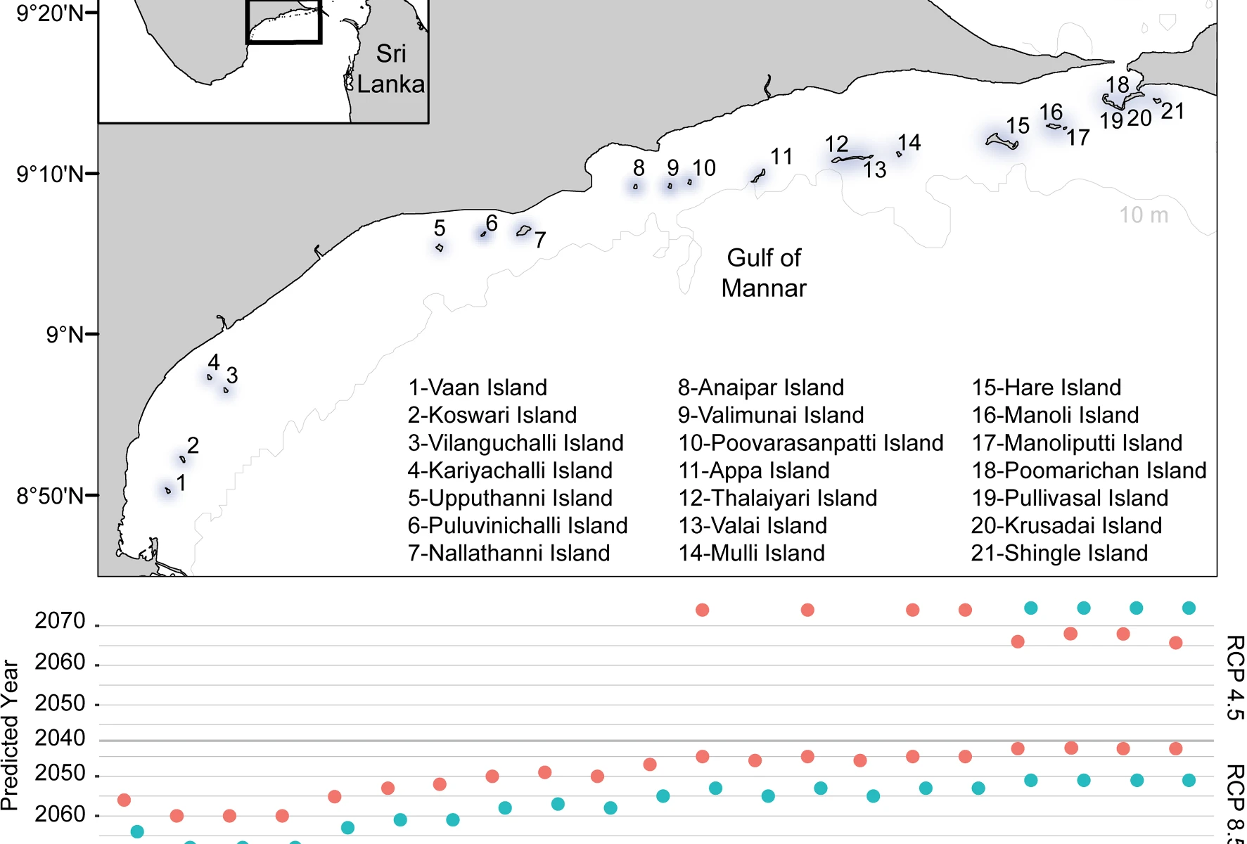
We used a 12-yr data set of benthic cover (2005–2017), spanning two bleaching events, to assess changes in benthic cover and coral community composition along 21 islands within Gulf of Mannar (GoM), southeast India. Overall, between 2005 and 2017 reefs had a simultaneous decrease in relative coral cover (avg. =  − 36%) and increase in algal cover (avg. =  + 45%). Changes in benthic cover were not consistent among islands, ranging from − 34 to + 5% for coral cover and from − 0.3 to + 50% for algae. There was a spatial gradient in coral mortality, which increased among islands from west to east. However, there was a disconnect between coral loss and subsequent increases in algae. Algal cover increased more on islands in west GoM where coral loss was minimal. Environmental co-factors (coral cover, percent bleaching, degree heating weeks, fish densities, Chl-a, pollution) explained > 50% of the benthic cover responses to successive bleaching. Coral survival was favored on islands with higher fish densities and chlorophyll-a levels, and increases in algal cover were associated with higher measures of pollution from terrestrial runoff. Coral morphotypes differed in their response following successive bleaching resulting in changes in the relative abundance of different coral morphotypes. Existing climate projections (RCP8.5) indicate a 22-yr gap in the onset of annual severe bleaching (ASB) for reefs in the east versus west GoM, and ASB was ameliorated for all reefs under the RCP4.5 projections. There is limited knowledge of the resilience of GoM reefs, and this study identifies coral morphotypes and reefs that are most likely to recover or decline from successive bleaching, in the context of forecasts of the frequency of future bleaching events in GoM.

[sendpaper paperurl=”raj_2021.pdf”]

Full Citation

Raj KD, Aeby GS, Mathews G, Williams GJ, Caldwell JM, Laju RL, Bharath MS, Kumar PD, Arasamuthu A, Asir NGG, Wedding LM, Davies AJ, Moritsch MM, Edward JKP (2021) Coral reef resilience differs among islands within the Gulf of Mannar, southeast India, following successive coral bleaching events. Coral Reefs 40: 1029-1044

Manuscript DOI

https://doi.org/10.1007/s00338-021-02102-0

Three‐dimensional mapping reveals scale‐dependent dynamics in biogenic reef habitat structure

Three‐dimensional mapping reveals scale‐dependent dynamics in biogenic reef habitat structure

Tim Jackson‐Bué, Gareth J. Williams, Guy Walker‐Springett, Steven J. Rowlands, Andrew J. Davies

Abstract

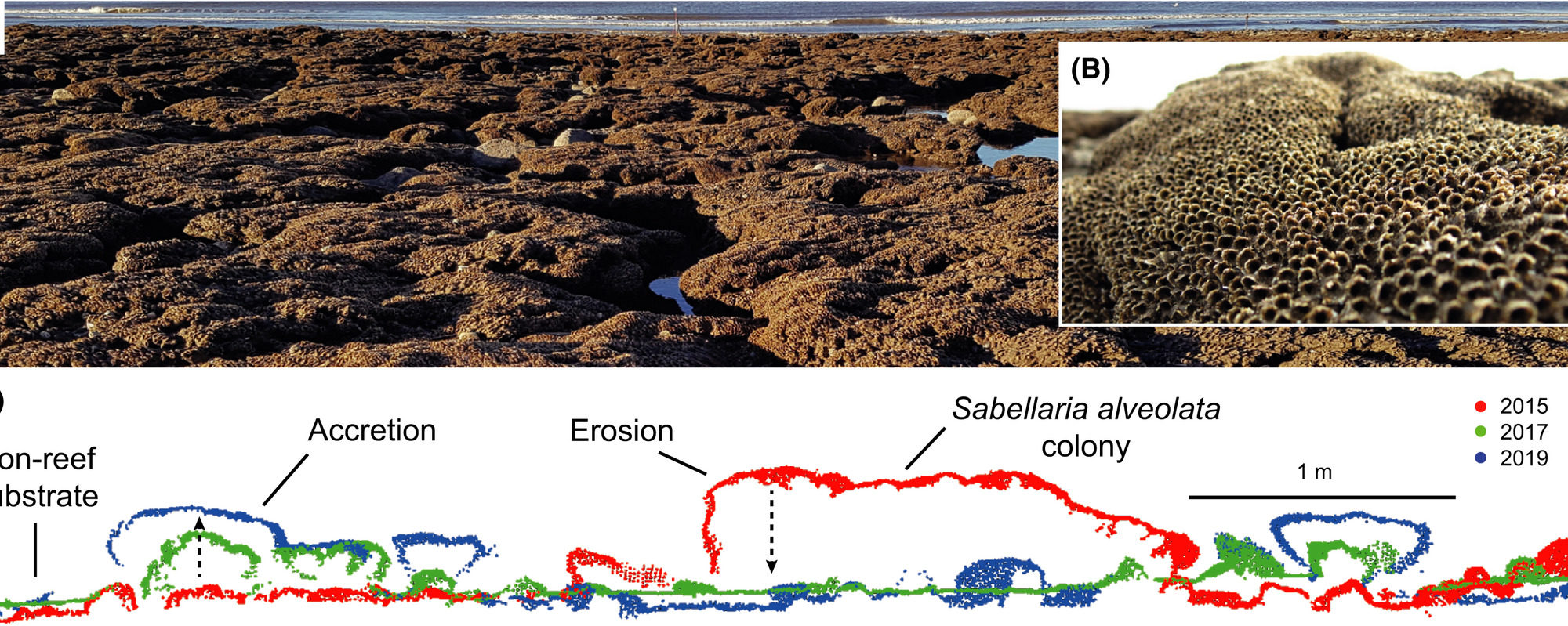
Habitat structure influences a broad range of ecological interactions and ecosystem functions across biomes. To understand and effectively manage dynamic ecosystems, we need detailed information about habitat properties and how they vary across spatial and temporal scales. Measuring and monitoring variation in three‐dimensional (3D) habitat structure has traditionally been challenging, despite recognition of its importance to ecological processes. Modern 3D mapping technologies present opportunities to characterize spatial and temporal variation in habitat structure at a range of ecologically relevant scales. Biogenic reefs are structurally complex and dynamic habitats, in which structure has a pivotal influence on ecosystem biodiversity, function and resilience. For the first time, we characterized spatial and temporal dynamics in the 3D structure of intertidal Sabellaria alveolata biogenic reef across scales. We used drone‐derived structure‐from‐motion photogrammetry and terrestrial laser scanning to characterize reef structural variation at mm‐to‐cm resolutions at a habitat scale (~35 000 m2) over 1 year, and at a plot scale (2500 m2) over 5 years (2014–2019, 6‐month intervals). We found that most of the variation in reef emergence above the substrate, accretion rate and erosion rate was explained by a combination of systematic trends with shore height and positive spatial autocorrelation up to the scale of colonies (1.5 m) or small patches (up to 4 m). We identified previously undocumented temporal patterns in intertidal S. alveolata reef accretion and erosion, specifically groups of rapidly accreting, short‐lived colonies and slow‐accreting, long‐lived colonies. We showed that these highly dynamic colony‐scale structural changes compensate for each other, resulting in seemingly stable reef habitat structure over larger spatial and temporal scales. These patterns could only be detected with the use of modern 3D mapping technologies, demonstrating their potential to enhance our understanding of ecosystem dynamics across scales.

Full Citation

Jackson‐Bué T, Williams GJ, Walker‐Springett G, Rowlands SJ, Davies AJ (2021) Three‐dimensional mapping reveals scale‐dependent dynamics in biogenic reef habitat structure. Remote Sensing in Ecology and Conservation 

Manuscript DOI

http://doi.org/10.1002/rse2.213

Habitat modification by Ascophyllum canopy negatively impacts macrofaunal communities on soft-sediment shores

Habitat modification by Ascophyllum canopy negatively impacts macrofaunal communities on soft-sediment shores

Gilson, AR & Davies AJ

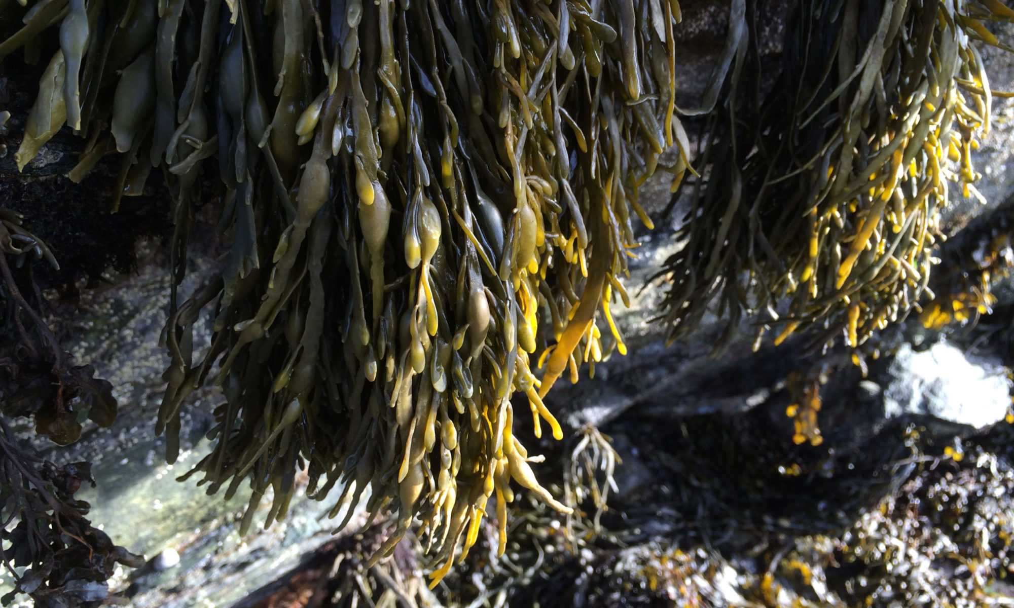
Canopy-forming macroalgae are known to act as ecosystem engineers, altering the physical parameters of the local environment, and as a result, driving changes in local biodiversity. Although a large body of evidence exists regarding macroalgal canopies on intertidal rocky shores, little is known regarding attached perennial species in soft sediment environments. The aim of this study was to assess whether the presence of an Ascophyllum nodosum canopy altered physical parameters, leading to the formation of different environmental conditions in the areas around the canopy and whether this led to changes in the local community. Sediment cores were taken in canopy-present and canopy-absent treatments at four sites over four sampling periods covering winter (November and January) through to spring (March and May) to assess modification of seven physical parameters: particle size, sand/silt/clay content, chlorophyll a, organic carbon, pore water content and temperature, as well as for macrofaunal diversity. Results revealed significant differences between treatments for all variables with the exception of clay content. Areas below the canopy were dominated by a high abundance of opportunistic species indicating a more disturbed environment, with increased levels of organic enrichment, anoxia and scouring found to be the principal sources of physical disturbance. In conclusion, differences in abiotic parameters between canopy and non-canopy areas in soft-sediment environments were driven both directly and indirectly by the presence of the algal canopy. This facilitated an alternative community composition that enhanced biodiversity within algal-sediment shores.
[sendpaper paperurl=”2020_Gilson.pdf”]

Full Citation

Gilson AR, Davies AJ (2020) Habitat modification by Ascophyllum canopy negatively impacts macrofaunal communities on soft-sediment shores. Marine Environmental Research 162: 105193

DOI

https://doi.org/10.1016/j.marenvres.2020.105193


Drivers of sex-specific trade-offs in the macroalga Ascophyllum nodosum

Drivers of sex-specific trade-offs in the macroalga Ascophyllum nodosum

Kurr M, Davies AJ

Little is known about reproductive trade-offs in seaweeds, but sex-specific differences in mortality, production of metabolites, threshold size for reproduction, and susceptibility to herbivory have been reported. The macroalga Ascophyllum nodosum exhibits sex-specific trade-offs at sites where wave-action and herbivory are stronger, because females increase their investment into reproduction at the expense of chemical defences. Females may do this at stressed sites because of high germling and juvenile mortality, or to compensate for lower fecundity due smaller adult sizes at these sites. This study aimed to determine which is the case by comparing A. nodosum in an area where stressors (wave-action and herbivory) impacted upon both adult performance and juvenile mortality, to one where only adult performance was impacted (by ice-damage). Seven populations of the algae were compared at both the regional (> 1000 km) and local scales (< 50 km), to assess the presence of sex-specific differences in algal size, sex-ratio, and the chemical defences and tissue condition of both vegetative and reproductive structures. Taking a multi-scale approach is a useful way to determine which abiotic variables are driving biological patterns, because variability in the latter mirrors variability in the former. Sex-specific trade-offs were more common at both the regional and local scale when herbivory and wave-exposure were high. Other factors caused differences in physiology at both scales, but did not drive sex-specific differences. Furthermore, sex-specific differences were consistent in the defence of reproductive tissues at all sites, suggesting that this was not driven by stress at all. Therefore, sex-specific differences in A. nodosum are caused by some stressors, not caused by others, and are present in some fashion regardless of stress. This is the first study to directly quantify sex-specific trade-offs at different spatial scales in populations of either plants or algae, and as such it reveals novel insights into the driving forces behind them.
[sendpaper paperurl=”2020_Kurr.pdf”]

Full Citation

Kurr M, Davies AJ (2020) Drivers of sex-specific trade-offs in the macroalga Ascophyllum nodosum. Plant 8 (3): 54-63.

DOI

http://dx.doi.org/10.11648/j.plant.20200803.12


Beyond the tip of the seamount: Distinct megabenthic communities found beyond the charismatic summit sponge ground on an arctic seamount (Schulz Bank, Arctic Mid-Ocean Ridge)

Beyond the tip of the seamount: Distinct megabenthic communities found beyond the charismatic summit sponge ground on an arctic seamount (Schulz Bank, Arctic Mid-Ocean Ridge)

H.K. Meyer, A.J.Davies, E.M.Roberts, J.R. Xavier, P.A. Ribeiro, H.Glenner, S.-R. Birkely, H.T.Rapp

Abstract

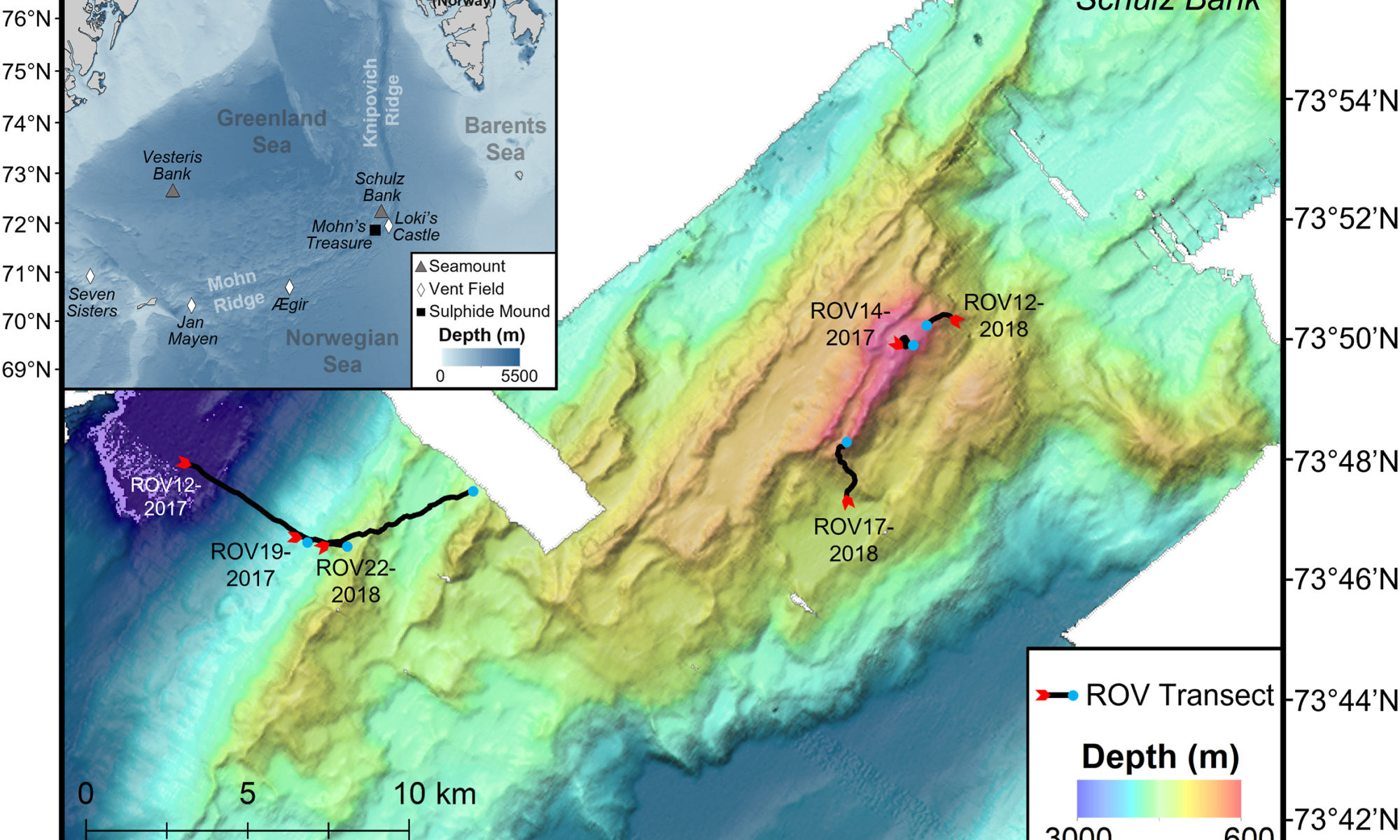
Our understanding of the benthic communities on arctic seamounts and descriptions of such communities in habitat classification systems are limited. In recent years, Schulz Bank (73°52′N 7°30′E), a seamount on the Arctic Mid-Ocean Ridge (AMOR), has become well studied but the work has primarily focused on an arctic sponge ground at the summit. This has compounded a general assumption that the most biologically interesting community is on the summit alone. With the potential threat of deep-sea mining on nearby sites on AMOR, it is crucial to form a baseline understanding of the benthic megafaunal communities not only on the summit, but on the slopes and base of the seamount as well. Using video footage collected by a remotely operated vehicle in 2017 and 2018 to survey the seamount from 2700 to 580 m depth, several distinct megafauna communities on Schulz Bank were identified. Specifically, five biotopes, two of which were dominated by large structure-forming sponges, appeared to follow a depth gradient and change with the type of substrata present. The sponge-dominated communities on the summit and lower slope had the highest average community densities and number of morphotaxa per image compared to the upper slope and seamount base communities. Most notably, sponge-dominated bedrock walls on the lower slopes challenge the assumption that the summit is the most dense and diverse community on Schulz Bank. The results from this study lay the foundation for future research and conservation efforts of arctic sponge grounds by looking beyond the seamount summit to bring a full view of enigmatic sponge dominated ecosystems.

[sendpaper paperurl=”2022_Meyer.pdf”]

Full Citation

Meyer HK, Davies AJ, Roberts EM, Xavier JR, Ribeiro PA, Glenner H, Birkely S_R, Rapp HT (2022) Beyond the tip of the seamount: Distinct megabenthic communities found beyond the charismatic summit sponge ground on an arctic seamount (Schulz Bank, Arctic Mid-Ocean Ridge). Deep-sea Research Vol 1

Manuscript DOI

https://doi.org/10.1016/j.dsr.2022.103920

Distribution modelling of the Eurasian Otter (Lutra lutra) on the Isle of Anglesey, Wales

Distribution modelling of the Eurasian Otter (Lutra lutra) on the Isle of Anglesey, Wales

Riley TG, Waggit JJ, Davies AJ

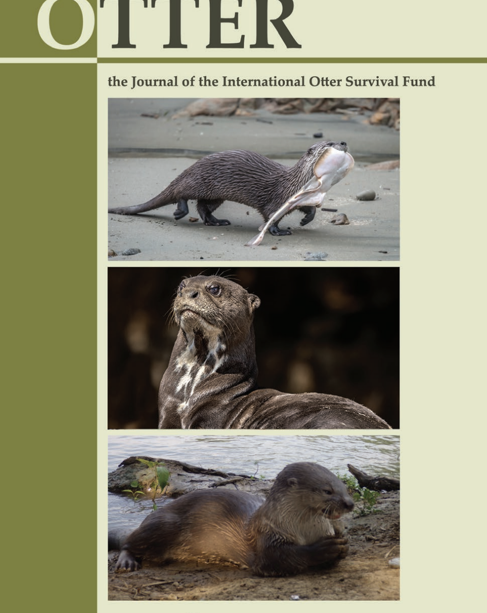
The Eurasian otter (Lutra lutra) remains a high priority conservation species despite recent increases in UK populations. Specifically, a marked increase in surveyed site occupancy (50%) was observed on the Isle of Anglesey (North Wales) between 2002 and 2009. Understanding the drivers that act upon the distribution of L. lutra will allow for more targeted conservation efforts. In this study, species distribution modelling (MaxEnt) was applied to predict the potential distribution of L. lutra across Anglesey. Elevation and, distance to roads and water (m) were found to be the most influential factors in determining the distribution of individuals across all models. The generated models performed better than random and were capable of identifying areas where L. lutra could potentially occur across Anglesey (AUC = 0.818). Locations for concentrating future research efforts are suggested through analysis of spatial variation, human disturbance effects and population analysis across the study region. This study provides a baseline of L. lutra habitation possibility across Anglesey and exposes areas for future conservation in habitat management and research efforts.
[sendpaper paperurl=”2020_Riley.pdf”]

Full Citation

Riley TG, Waggit JJ, Davies AJ (2020) Distribution modelling of the Eurasian Otter (Lutra lutra) on the Isle of Anglesey, Wales. Otter, Journal of the International Otter Survival Fund 6: 30-39


Spatial scaling properties of coral reef benthic communities

Helen’s paper made the cover of Ecography

Spatial scaling properties of coral reef benthic communities

Ford HV, Gove JM, Davies AJ, Graham NAJ, Healey JR, Conklin EJ, Williams GJ

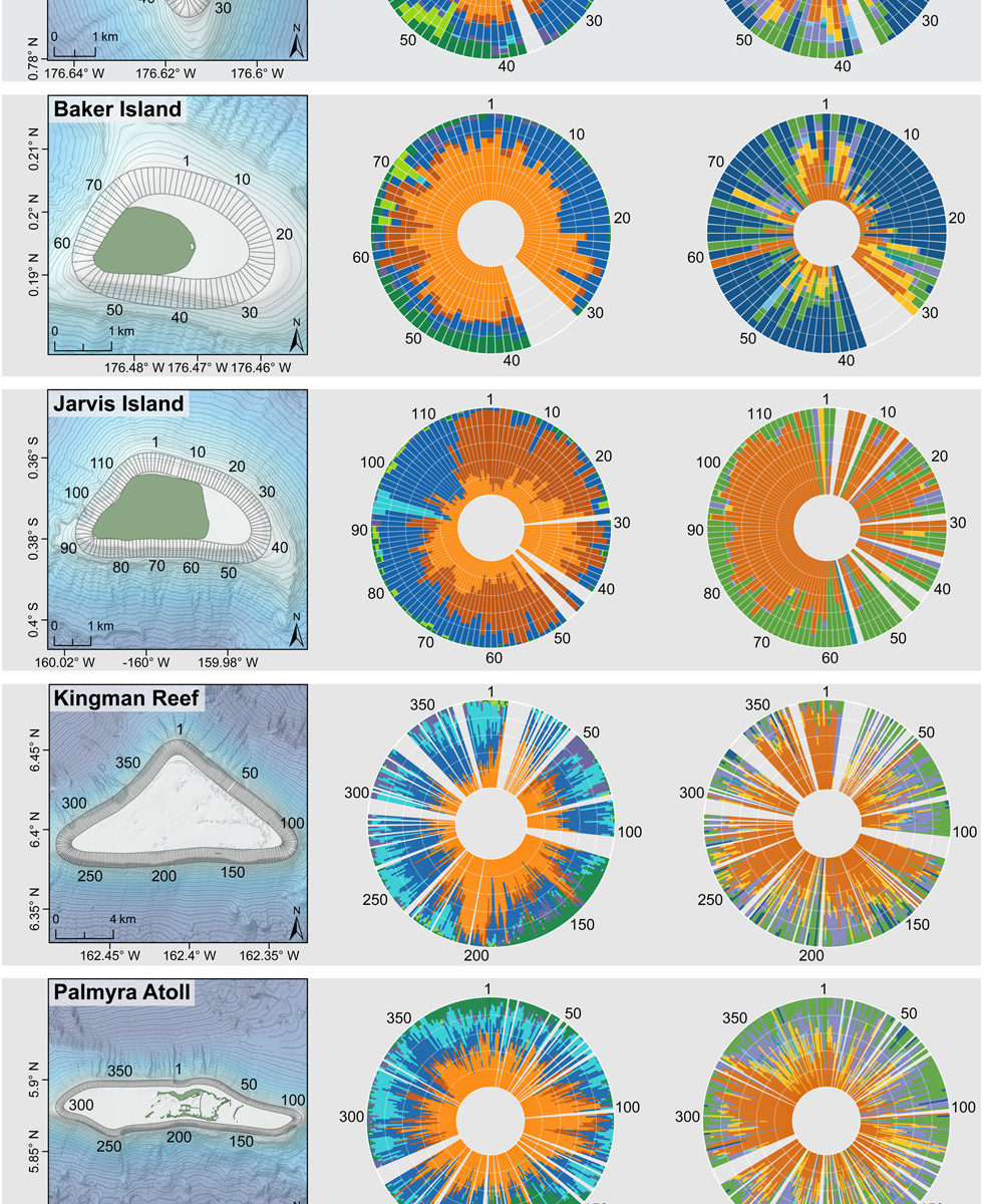
The spatial structure of ecological communities on tropical coral reefs across seascapes and geographies have historically been poorly understood. Here we addressed this for the first time using spatially expansive and thematically resolved benthic community data collected around five uninhabited central Pacific oceanic islands, spanning 6° latitude and 17° longitude. Using towed-diver digital image surveys over ~140 linear km of shallow (8–20 m depth) tropical reef, we highlight the autocorrelated nature of coral reef seascapes. Benthic functional groups and hard coral morphologies displayed significant spatial clustering (positive autocorrelation) up to kilometre-scales around all islands, in some instances dominating entire sections of coastline. The scale and strength of these autocorrelation patterns showed differences across geographies, but patterns were more similar between islands in closer proximity and of a similar size. For example, crustose coralline algae (CCA) were clustered up to scales of 0.3 km at neighbouring Howland and Baker Islands and macroalgae were spatially clustered at scales up to ~3 km at both neighbouring Kingman Reef and Palmyra Atoll. Of all the functional groups, macroalgae had the highest levels of spatial clustering across geog- raphies at the finest resolution of our data (100 m). There were several cases where the upper scale at which benthic community members showed evidence of spatial cluster- ing correlated highly with the upper scales at which concurrent gradients in physical environmental drivers were spatially clustered. These correlations were stronger for surface wave energy than subsurface temperature (regardless of benthic group) and turf algae and CCA had the closest alignments in scale with wave energy across functional groups and geographies. Our findings suggest such physical drivers not only limit or promote the abundance of various benthic competitors on coral reefs, but also play a key role in governing their spatial scaling properties across seascapes.

var $j = jQuery.noConflict();

$j(window).load(function(){

$j(“#send-paper”).submit(function() {

var str = $j(this).serialize();

$j.ajax({
type: “POST”,
url: “https://anddavies.co.uk/wp-content/plugins/emailarticleshortcode/sendpaper.php”,
data: str,
success: function(msg){

if(msg == “OK”) // Message Sent? Show the Thank You message and hide the form
{
result = “
Your paper has been sent. Check your email and in rare occasions your Junk Mail folder. It should be with you in a few minutes, if you do not get it, email me directly. Thank you!

“;
$j(“div#fields”).hide();
$j(“div#note”).html(result);
}
else
{
result = msg;
$j(“div#note”).html(result);
}

}
});
return false;
});
});

Request PDF

To request a PDF copy of this paper, please enter your email address below:

Your email address is not stored, it is only used to send an email with an attached PDF to you.

Full Citation

Ford HV, Gove JM, Davies AJ, Graham NAJ, Healey JR, Conklin EJ, Williams GJ (2021) Spatial scaling properties of coral reef benthic communities. Ecography 44(2): 188-198

DOI

http://dx.doi.org/10.1111/ecog.05331

Submarine canyons influence macrofaunal diversity and density patterns in the deep-sea benthos

Submarine canyons influence macrofaunal diversity and density patterns in the deep-sea benthos

Robertson CM, Demopoulos AWJ, Bourque JR, Mienis F, Duineveld GCA, Lavaleye MSS, Koivisto RKK, Brooke SD, Ross SW, Rhode M, Davies AJ

Submarine canyons are often morphologically complex features in the deep sea contributing to habitat heterogeneity. In addition, they act as major conduits of organic matter from the shallow productive shelf to the food deprived deep-sea, promoting gradients in food resources and areas of sediment resuspension and deposition. This study focuses on the Baltimore and Norfolk canyons, in the western North Atlantic Ocean, and investigates how different biogeochemical drivers influence canyon and slope macrofaunal communities. Replicated sediment cores were collected along the main axes (~180–1200 m) of Baltimore and Norfolk canyons and at comparable depths on the adjacent slopes. Cores were sorted, assessing whole community macrofaunal (>300 μm) abundance, diversity and standing stocks. Canyon communities were significantly different from slope communities in terms of diversity, abundance patterns and community assemblages, which were attributed to high levels of organic matter enrichment within canyons. There was a significant departure from the expected density-depth relationship in both canyons, driven by enhanced abundances between 800 and 900 m canyon depths, which was characterised as a deposition zone for organic matter. Bathymetric zonation, sediment dynamics, organic enrichment, and disturbance events were clear factors that structured the benthic communities in both Baltimore and Norfolk canyons. Coupling family-level community data, with sediment grain-size and biogeochemistry data explained community dynamics across depth and biogeochemical gradients, providing further evidence that canyons disrupt macrofaunal diversity and density patterns in the deep-sea benthos.
[sendpaper paperurl=”2020_Robertson.pdf”]

Full Citation

Robertson CM, Demopoulos AWJ, Bourque JR, Mienis F, Duineveld GCA, Lavaleye MSS, Koivisto RKK, Brooke SD, Ross SW, Rhode M, Davies AJ (2020) Submarine canyons influence macrofaunal diversity and density patterns in the deep-sea benthos. Deep Sea Research Part I: Oceanographic Research Papers.

DOI

https://doi.org/10.1016/j.dsr.2020.103249


Climate‐induced changes in the suitable habitat of cold‐water corals and commercially important deep‐sea fishes in the North Atlantic

Climate‐induced changes in the suitable habitat of cold‐water corals and commercially important deep‐sea fishes in the North Atlantic

Morato T, González‐Irusta, JM, Dominguez‐Carrió C, Wei C-L, Davies AJ and others

https://onlinelibrary.wiley.com/doi/full/10.1111/gcb.14996

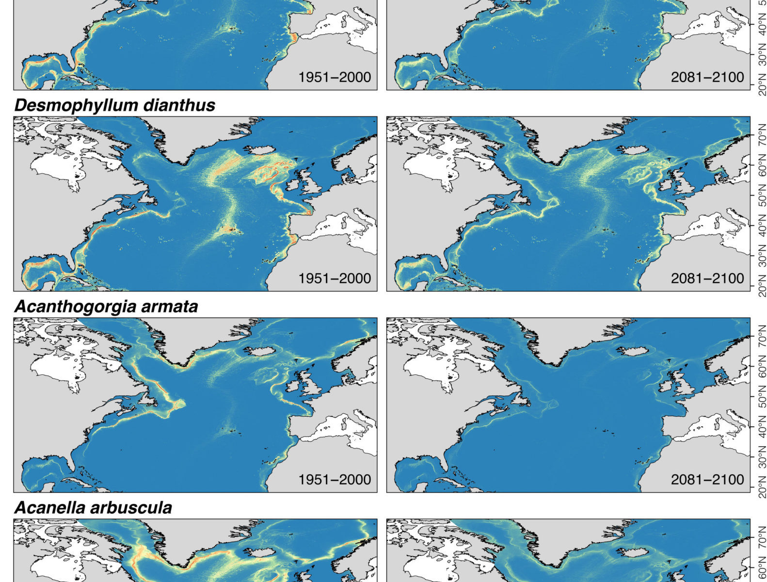
The deep sea plays a critical role in global climate regulation through uptake and storage of heat and carbon dioxide. However, this regulating service causes warming, acidification and deoxygenation of deep waters, leading to decreased food availability at the seafloor. These changes and their projections are likely to affect productivity, biodiversity and distributions of deep‐sea fauna, thereby compromising key ecosystem services. Understanding how climate change can lead to shifts in deep‐sea species distributions is critically important in developing management measures. We used environmental niche modelling along with the best available species occurrence data and environmental parameters to model habitat suitability for key cold‐water coral and commercially important deep‐sea fish species under present‐day (1951–2000) environmental conditions and to project changes under severe, high emissions future (2081–2100) climate projections (RCP8.5 scenario) for the North Atlantic Ocean. Our models projected a decrease of 28%–100% in suitable habitat for cold‐water corals and a shift in suitable habitat for deep‐sea fishes of 2.0°–9.9° towards higher latitudes. The largest reductions in suitable habitat were projected for the scleractinian coral Lophelia pertusa and the octocoral Paragorgia arborea, with declines of at least 79% and 99% respectively. We projected the expansion of suitable habitat by 2100 only for the fishes Helicolenus dactylopterus and Sebastes mentella (20%–30%), mostly through northern latitudinal range expansion. Our results projected limited climate refugia locations in the North Atlantic by 2100 for scleractinian corals (30%–42% of present‐day suitable habitat), even smaller refugia locations for the octocorals Acanella arbuscula and Acanthogorgia armata (6%–14%), and almost no refugia for P. arborea. Our results emphasize the need to understand how anticipated climate change will affect the distribution of deep‐sea species including commercially important fishes and foundation species, and highlight the importance of identifying and preserving climate refugia for a range of area‐based planning and management tools.